 Filter: Categories of Wisconsin Historical Images
Filter: GENRE of Map or Atlas
Filter: Year of 1900-1999
Filter: Categories of Wisconsin Historical Images
Filter: GENRE of Map or Atlas
Filter: Year of 1900-1999

| Date: | 1936 |
|---|---|
| Description: | This map is red and black ink on tracing cloth and is oriented with north to the upper left. This hand-drawn map shows a central portion of the military ro... |

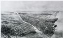
| Date: | 1908 |
|---|---|
| Description: | Colored map showing a panoramic view of Madison in great detail. The Wisconsin State Capitol is located at the center, with Lake Mendota in the background ... |

| Date: | 1908 |
|---|---|
| Description: | Five volumes of the Crown Collection of American Maps, plus an index, showing the spines of these books. |

| Date: | 1926 |
|---|---|
| Description: | Pages 21 and 22 from the 1926 schedule are a map showing the routes of the Goodrich Transit Company, Great Lakes Transit Company, Detroit and Cleveland Lin... |

| Date: | 1930 |
|---|---|
| Description: | Page 8 of the 1930 schedule is a map of the routes of the Goodrich Steamship Lines in Lake Michigan and Lake Huron. |

| Date: | 1926 |
|---|---|
| Description: | Map of the routes of the screw-driven passenger/freight vessels of the Michigan Transit Company for 1926. |

| Date: | 1930 |
|---|---|
| Description: | Map of the routes of the screw passenger and freight vessels of the Michigan Transit Company. Includes a picture of the Park Place hotel in Traverse City, ... |

| Date: | 1910 |
|---|---|
| Description: | Map of Dane County rural delivery in Madison and the town of Westport. |

| Date: | 1916 |
|---|---|
| Description: | Map of all automobile roads out of Madison, compliments of the Madison Board Of Commerce. |

| Date: | 1910 |
|---|---|
| Description: | Map of the general plan of the district of the Four Lakes. |

| Date: | 1923 |
|---|---|
| Description: | Map of Oneida County-Rhinelander Airport which was laid out at the county fairgrounds. The map appears on the reverse side of a letter Roy Larson received ... |

| Date: | 1907 |
|---|---|
| Description: | Bird's-eye map of Chippewa Falls with insets of Chippewa Lumber & Boom Co., Opera House Block, Chippewa Falls Furniture Co., and J. Leinenkugel Brewing Co. |

| Date: | 1906 |
|---|---|
| Description: | Bird's-eye map of South Milwaukee. |

| Date: | 1913 |
|---|---|
| Description: | Bird's-eye map of Superior. "The New Steel Center." |

| Date: | 1915 |
|---|---|
| Description: | Bird's-eye view of Superior, Wisconsin, and Duluth, Minnesota on opposite shore of Lake Superior. |

| Date: | 1914 |
|---|---|
| Description: | This map shows Sheboygan in 1914. The top of the map has the date of "NOV 17 1916" stamped in red ink. The map shows numbered plots and labeled streets, an... |

| Date: | 1927 |
|---|---|
| Description: | Color map, hand-drawn with comic figures engaged in various activities throughout map. Bordered by the river on the left and Lake Michigan on the right, in... |
| Date: | 1911 |
|---|---|
| Description: | Black and white image, looking west from Lake Winnebago with Fox River flowing from top left corner to bottom right corner. Streets laid out with indicatio... |

| Date: | 1910 |
|---|---|
| Description: | Bird's-eye view looking east, with Washburn Harbor at center and Chequamegon Bay in Lake Superior covering most of the upper image. Streets with buildings ... |
If you didn't find the material you searched for, our Library Reference Staff can help.
Call our reference desk at 608-264-6535 or email us at:
