 Filter: Categories of Wisconsin Historical Images
Filter: FORMAT_TYPE of prints, fine-art
Filter: Year of 1700-1799
Filter: Categories of Wisconsin Historical Images
Filter: FORMAT_TYPE of prints, fine-art
Filter: Year of 1700-1799
| Date: | 1784 |
|---|---|
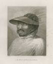
| Description: | Plate 48. Portrait from Cook's Third Expedition, 1776-1779, while in Alaska. |
| Date: | 1784 |
|---|---|
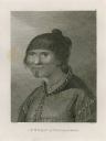
| Description: | Plate 49. Portrait from Cook's Third Expedition, 1776-1779, while in Alaska. |

| Date: | 1784 |
|---|---|
| Description: | Plate 57. Scene from Cook's Third Expedition, 1776-1779, while in Alaska. |

| Date: | 1778 |
|---|---|
| Description: | Hand-colored. London, 1778. Coordinates: W 99⁰--W 83⁰/N 49⁰--N 41⁰. Scale [ca. 1:3,500,000] |

| Date: | 09 19 1787 |
|---|---|
| Description: | The first printing of the United States Constitution found in the "Pennsylvania Packet," and "Daily Advertiser." |

| Date: | 09 19 1787 |
|---|---|
| Description: | The first printing of the United States Constitution found in the "Pennsylvania Packet," and "Daily Advertiser." |

| Date: | 1720 |
|---|---|
| Description: | Double hemispherical world map showing routes of Tasman, Magellan, Mendana, etc. Relief shown pictorially. Title in oak wreath cartouche. Map between four ... |

| Date: | 1740 |
|---|---|
| Description: | From Weigel's Atlas portatilis, oder, Compendieuse Vorstellung der gantzen Welt. Map of Europe. |

| Date: | 1712 |
|---|---|
| Description: | Engraved double-hemispherical world map by Moll, included in his atlas The world described, or, A new and correct sett of maps: shewing the kingdoms and st... |

| Date: | 1798 |
|---|---|
| Description: | Engraved and hand-colored map of Egypt. Map title appears on bottom left as a carving in stone next to a statue of a sphinx. |

| Date: | 1740 |
|---|---|
| Description: | Engraved and hand-colored map of the Iberian peninsula as a theater of war during the War of the Spanish Succession (1701-1714). The map is dedicated to Ki... |

| Date: | 1785 |
|---|---|
| Description: | Map of part of North America engraved and hand-colored (the light brown design is a superposition of the map and cartouche derived from the oxidation of th... |

| Date: | 02 01 1793 |
|---|---|
| Description: | Text in the upper right corner reads, "A Map of The Western Part of the Territories belonging to the United States of America. Drawn from the best authorit... |

| Date: | 1760 |
|---|---|
| Description: | A map of the world in two hemispheres, with the borders of the continents hand-colored. This map contains 14 spherical diagrams of the cosmos, portraying t... |

| Date: | 1715 |
|---|---|
| Description: | A map of the countries and islands surrounding the Gulf of Mexico. The hand-colored borders separate the territories of England, France, Spain, and Holland... |

| Date: | 1721 |
|---|---|
| Description: | A map of North and South America with an elaborately illustrated cartouche depicting Native Americans in upper left corner. The map is fairly detailed, dep... |

| Date: | 1735 |
|---|---|
| Description: | A map of the western hemisphere, including parts of western Europe and Africa. Portraits of explorers, such as Jacques Marquette, Louis Joliet, and Robert ... |

| Date: | 1739 |
|---|---|
| Description: | This map shows the territorial claims of the western hemisphere by the European powers, as well as the names of major cities, geographical features, and pa... |

| Date: | 1746 |
|---|---|
| Description: | A map of the western hemisphere, including parts of western Europe and Africa, showing the division of the Americas by the European powers. Weapons and fol... |

| Date: | 1761 |
|---|---|
| Description: | This map shows the western hemisphere. Much of the north-west coast of North America is left blank, but the rest of the map lists the names of rivers, citi... |
If you didn't find the material you searched for, our Library Reference Staff can help.
Call our reference desk at 608-264-6535 or email us at: