 Filter: Categories of Wisconsin Historical Images
Filter: Subject of Wisconsin
Filter: Community of Prairie du Chien
Filter: Categories of Wisconsin Historical Images
Filter: Subject of Wisconsin
Filter: Community of Prairie du Chien
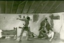
| Date: | 1940 |
|---|---|
| Description: | Photograph of a painting by Cal Peters depicting the Winnebago attack on the Gagnier homestead in 1827 and the killing of Registre Gagnier. The homestead w... |

| Date: | 1838 |
|---|---|
| Description: | This map is a development plat that shows street names, numbered blocks and lots, and small farm lot owners. Included on the right of the map is a large am... |

| Date: | |
|---|---|
| Description: | This map is pen-and-ink on tracing paper with a mounted legend and shows the Kickapoo River, Indian mounds, the 1st Fort Crawford, an Indian Agency, the si... |

| Date: | 1900 |
|---|---|
| Description: | This map shows a line, marked with latitude and longitude coordinates that runs through Prairie du Chien. Only a few features beyond this line are displaye... |
If you didn't find the material you searched for, our Library Reference Staff can help.
Call our reference desk at 608-264-6535 or email us at: