 Filter: Categories of Wisconsin Historical Images
Filter: Subject of Minnesota
Filter: Subject of minnesota
Filter: Categories of Wisconsin Historical Images
Filter: Subject of Minnesota
Filter: Subject of minnesota

| Date: | 10 1852 |
|---|---|
| Description: | Landscape view of the river looking downstream from Fort Snelling, Minnesota Territory. An expanse of placid river water fills the center of the drawing an... |

| Date: | 1688 |
|---|---|
| Description: | This map includes vignettes of Amerindian life with text describing geography, culture, and exploration activity, written in French. The Great Lakes, river... |

| Date: | 1851 |
|---|---|
| Description: | A survey map of Wisconsin and eastern Minnesota, with the township surveys for portions of the Saint Croix region in progress. The maps also show the Menom... |

| Date: | 1836 |
|---|---|
| Description: | This map was created to accompany a congressional report shows the then Wisconsin Territory, including present-day states of Wisconsin, Minnesota, Iowa, an... |

| Date: | 1836 |
|---|---|
| Description: | This map was created to accompany a congressional report shows the then Wisconsin Territory, including present-day states of Wisconsin, Minnesota, Iowa, an... |

| Date: | 1845 |
|---|---|
| Description: | This map shows lakes, rivers, Chippewa land, the U.S. Mineral Land Agency, boundary between U.S. and Canada, Methodist and Catholic missions, and American ... |
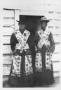
| Date: | |
|---|---|
| Description: | Two Ojibwa women in the Mille Lacs and Rainy Lake standing in front of a doorway. They are wearing traditional Indian attire, including beaded bandolier ba... |

| Date: | |
|---|---|
| Description: | A Native American man from the Mille Lacs and Rainy Lake area in Minnesota. He is probably Chippewa (Ojibwa). Behind him are paddles leaning on a tree and ... |
If you didn't find the material you searched for, our Library Reference Staff can help.
Call our reference desk at 608-264-6535 or email us at: